The Conversation (0)
Science & Tech
The extraordinary Saint-Bélec slab could help drive a flood of new archeological discoveries
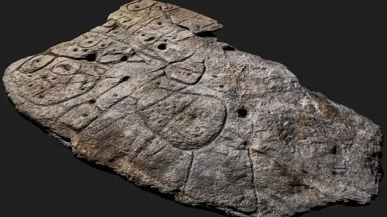
A humble piece of rock that was unearthed in north-western France has proven to be worth its weight in gold, with archaeologists hailing it as a “treasure map”.
The 4,000-year-old slab was named Europe’s oldest map by researchers back in 2021, and they have been poring over it ever since.
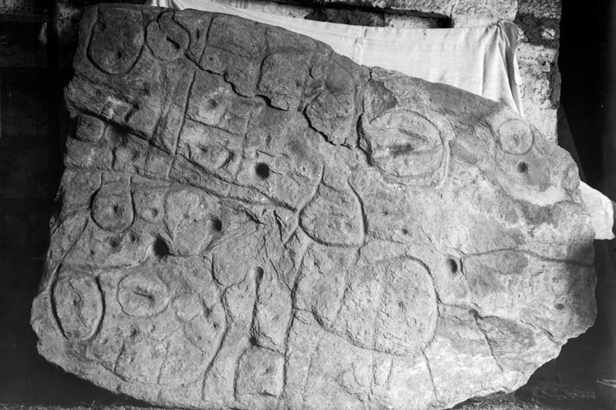
The fascination with the so-called Saint-Bélec stone lies in the mysterious symbols etched onto its surface.
While the local historian who initially discovered the rock back in 1900 was unable to decipher the engravings, experts are increasingly excited by the secrets they could unlock.
"It's a treasure map," Yvan Pailler, a professor at the University of Western Brittany (UBO), told the AFP news agency.
He explained that the almost two-metre-long rock could detail the locations of numerous archaeological sites.
Generally, such sites are uncovered using sophisticated radar equipment, aerial photography or, simply, by accident in cities when the foundations for new buildings are being dug.
But Pailler and his colleagues say the coarse bumps and lines of the slab correspond to notable landmarks, while smaller holes knocked into its surface could indicate other doorways into the past.
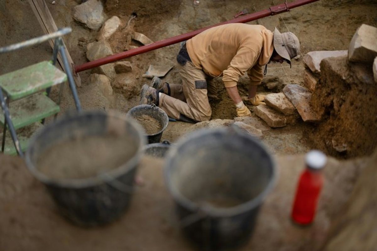 An archaeologist excavates the site in Leuhan, western France, where the slab was foundAFP
The ancient map marks an area of roughly 30km by 21km and Pailler's colleague, Clement Nicolas from the CNRS research institute, said they would need to survey the entire territory and cross-reference the markings on the slab.
That job could take 15 years, he said.
Nicolas and Pailler were part of the team that rediscovered the slab in 2014, more than a century after it was uncovered by historian Paul du Chatellier who failed to grasp its significance.
The French experts were joined by colleagues from other institutions in France and overseas as they began to decode its mysteries.
"There were a few engraved symbols that made sense right away," Pailler said.
In the lumps and grooves of the rock, they could see the rivers and mountains of Roudouallec, part of the Brittany region about 500km west of Paris.
The researchers scanned the stone and compared it with current maps, finding a roughly 80 per cent match.
"We still have to identify all the geometric symbols, the legend that goes with them," Nicolas stressed.
The slab is pocked with tiny hollows, which researchers believe could point to burial mounds, settlements or other sites of interest.
Discovering their meaning could lead to a whole flood of new finds.
 The slab was first uncovered by historian Paul du Chatellier in 1900 who was unable to decipher its engravingsArchives departementales du Finistere/AFP
But first, the archaeologists have spent the past few weeks digging at the site where the slab was initially uncovered, which Pailler said was one of the biggest Bronze Age burial sites in Brittany.
"We are trying to better contextualise the discovery, to have a way to date the slab," said Pailler.
Their latest dig has already turned up a handful of previously undiscovered fragments from the rock.
The pieces had apparently been broken off and used as a tomb wall, in what Nicolas suggests could signify the shifting power dynamics of Bronze Age settlements.
The area covered by the map probably corresponds to an ancient kingdom, perhaps one that collapsed in revolts and rebellions.
"The engraved slab no longer made sense and was doomed by being broken up and used as building material," said Nicolas.
Now, its pieces are helping to build up our picture of the past.
Sign up for our free Indy100 weekly newsletter
Have your say in our news democracy. Click the upvote icon at the top of the page to help raise this article through the indy100 rankings.