


The Conversation (0)
Greg Evans
Jan 07, 2020
Picture:
ABC News/ MyFireWatch
The wildfires in Australia have produced some of the most devastating images that the world has seen for years as flames have killed people, disintegrated countryside and destroyed close to a billion animals.
While people have been encouraged to donate what they can to help those effected another phenomenon has occurred thanks to this tragedy.
Over the bast few weeks on social media, you have seen a variety of maps which illustrate the overwhelming extent of the fires across the country and just how vast they are.
Here are a few examples.
Unfortunately, neither of those images accurately reflect what is actually happening in Australia right now.
A report by BuzzFeed showed that the first map has been created using a website called MyFireWatch which uses satellite data to display sources of heat and not exclusively fires.
It also uses a colour scheme to show the severity of the fire over the past 12 hours and if action should be taken or not.
Therefore the fires in the above map are not all wildfires like you have seen on the news in the past few weeks. They could just simply be a fire in someone's back garden.
It should be noted that the user who posted the second tweet has since apologised and explained that the map is not accurate.
BuzzFeed reports that the image was taken from a non-government website that illustrates brushfires that took place between 1997 and 2008, an 11 year period.
BuzzFeed, as well as Polifact, have debunked the third image in the above tweets.
The photo which is described as being taken by NASA is actually a 3D design of Australia using digital visualisations of fire data from the past 8 months.
In was created by graphic designer Anthony Hearsey who uploaded the image to Instagram and addressed the fact that the image was being shared with false information.
Unfortunately, the image has since been shared by Rihanna which has lead to people telling the singer that she is sharing fake news.
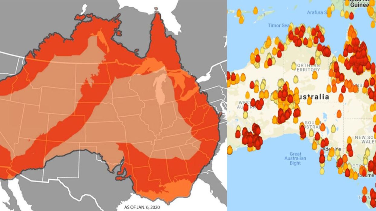
Another victim of sharing fake images of the fires has astonishingly been ABC News, who shared a confusing picture of an orange Australia superimposed on the top of the United States.
The map doesn't exactly show where any fires are but simply shows how big Australia is compared to the United States, which is misleading as maps are rarely accurate of the actual sizes of countries.
As recently as today, Fox News has shared a map of the fires which is inaccurate and has been called out for it on Twitter.
Away from maps, images of a dog that has apparently rescued a koala bear from the fires has begun to appear on social media.
While this picture isn't fake it is not related to the wildfires and was reported by news.com.au in September 2018, when the koala in Victoria sought a warm refuge after being separated from its mother as temperatures plummeted.
With this in mind, please be careful the next time you encounter such images on social media and do some research before you decide to share it with your friends.
H/T: BuzzFeed
More: Six ways you can help the victims of the Australian wildfires