The Conversation (0)
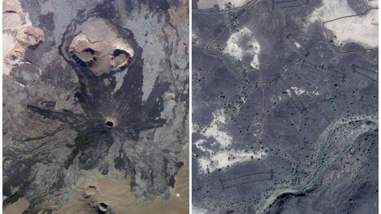
Harrat Khaybar is home to stunning volcanic formations and mysterious manmade structures (pictured right)
(NASA/CNES/Airbus, via Google Earth)
Harrat Khaybar is likened to the “gates of hell” for a reason.
The volcanic field, one of the largest in Saudi Arabia, stretches some 14,000 square km across the desert landscape, to the northeast of the city of Medina.
Its spectacular pockmarks and landforms tell of its past as a literal hotbed of volcanic activity.
These dramatic scars were formed by eruptions which occurred over five million years, with the most recent event recorded between 600 and 700AD, according to NASA.
However, despite once being one of the most inhospitable places on the planet, archaeologists have found evidence that humans once settled here, amid the lava flow.
"Enigmatic circular stone formations, reminiscent of those found in Europe, are scattered throughout this arid country on hilltops and valleys remote from human habitation," the Sydney Morning Herald first reported in 1977.
However, it was only with the more recent development of satellite images that these formations have been identified as the remains of Neolithic communities.
Experts now consider the Khaybar area “unique” because of the large variety of structures and their extraordinary preservation by the arid local climate.
Indeed, in 2018, the European Geosciences Union (EGU) hailed it as “complete prehistoric landscape frozen in time”.
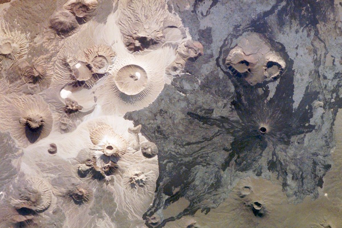 Harrat Khaybar pictured from the ISS(NASA)
The structures, of which there are around 400 and which date back up to 9,000 years, consist of volcanic stones, which were used to build villages, fences and more “enigmatic structures” such as what are known as “kites” and “gates”, the EGU notes.
So-called "desert kites" are largely understood to be stone fences that were probably used as animal traps.
However, according to the EGU, it’s possible that these hunting traps weren’t designed to capture and kill animals, and rather they could represent a first attempt of domestication of animals.
Meanwhile, some of the “gates” – named as such because they resemble field gates from above – are actually located on the side of a volcanic dome that once spewed out basaltic lava, researchers found.
The gates "are stone-built, the walls roughly made and low," David Kennedy, a professor at the University of Western Australia, wrote in a 2017 paper, and "appear to be the oldest man-made structures in the landscape."
And yet, he admitted, "no obvious explanation of their purpose can be discerned."
"Gates are found almost exclusively in bleak, inhospitable lava fields with scant water or vegetation, places seemingly amongst the most unwelcoming to our species," he wrote.
“They don't look like structures where people would have lived nor do they look like animal traps or for disposing of dead bodies,” he added in an interview with the New York Times.
“It’s a mystery as to what their purpose would have been.”
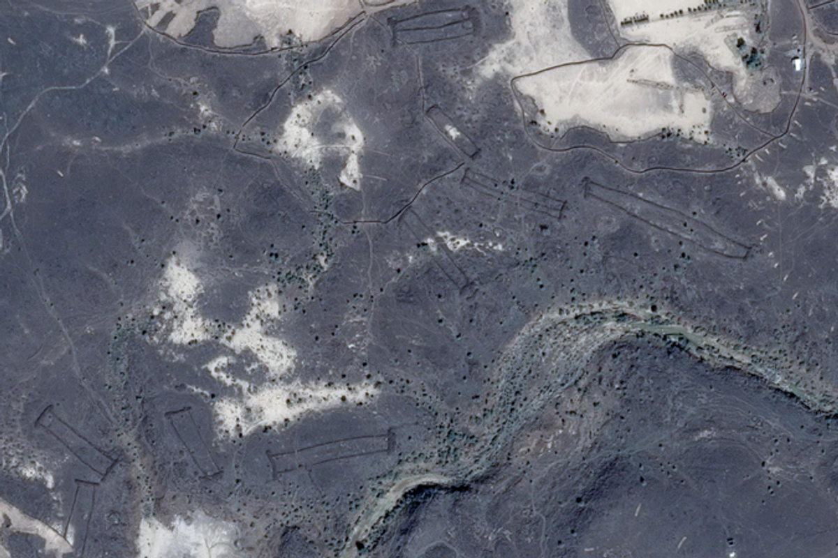 Archaeologists used Google Earth to locate and examine the mysterious 'gates'(CNES/Airbus, via Google Earth)
Still, Kennedy’s colleague, Dr Hugh Thomas, a Lecturer in Archaeology at the University of Sydney, at least shed some light on how populations could have lived in such a volatile environment.
He told Arab News in 2022: “The reality is that in the Neolithic period these areas were significantly greener, and there would have been really sizeable populations of people and herds of animals moving across these landscapes.”
Thomas, Kennedy and other researchers spent years searching for the gates and documenting their whereabouts thanks to Google Earth.
“We would have loved to fly across into Saudi Arabia to take images. But you never get the permission,” Kennedy told the New York Times.
It is for that reason they so heavily relied on the search engine's satellite programme.
“We tend to think of Saudi Arabia as desert, but in practice, there’s a huge archaeological treasure trove out there and it needs to be identified and mapped,” Kennedy added.
"You can’t see them very well from the ground level, but once you get up a few hundred feet, or with a satellite even higher, they stand out beautifully.”
This article was originally published on 26 March 2024
Why not read...
- Scientists discover that people who live past 90 have key differences in their blood
- A scientist may have just proven that we all live inside a computer simulation
- Scientists have discovered two giant mystery structures lurking under Africa
- Scientists discover continent that had been missing for 375 years
Sign up for our free Indy100 weekly newsletter
Have your say in our news democracy. Click the upvote icon at the top of the page to help raise this article through the indy100 rankings
Top 100