The Conversation (0)
Science & Tech
The ancient Romans are credited with building road networks, but a new digital atlas shows these stretched 50 per cent longer than previously estimated.
The research published recently is a new update to an atlas published 25 years ago, and during this time, there have been technological advancements and newly accessible sources that have enabled researchers to refine the location of these roads from way back in the day.
A combination of methods was used over a five-year period, such as looking at historical records, ancient journals, and milestone locations, plus using satellite imagery, aerial photography and digitised World War II photos to assist with their research.
 The Associated Press
If there was an inkling of a road from historical records, this location would be analysed for clues, and the type of tests would look at vegetation, soil variations, or shifts in elevation, or raised mounds or cut hillsides that were made by the Romans.
“It becomes a massive game of connecting the dots on a continental scale,” said Tom Brughmans, an archaeologist and co-author of the study published in Scientific Data, based at Aarhus University in Denmark, as per The Associated Press.
According to Brughmans, “the highways of the Roman Empire” often mentioned in historical accounts had been the earlier research focus.
He added how this latest update provides more information regarding “secondary roads, like the country lanes, that connected villas and farms.
Before this latest study, it was previously believed by experts that Roman roads covered around 117,163 miles (188,555 kilometers), but now we know this figure to be more at nearly nearly 186,000 miles (300,000 kilometers).
Through the study, more was understood about the Roman roads which extended to North Africa, the plains of France and in the Peloponnese peninsula of Greece.
“This will be a very foundational work for a lot of other research,” said archaeologist Benjamin Ducke of the German Archaeological Institute in Berlin, who was not involved in the project.
However, he noted that it remains unclear as to whether all the roads were active simultaneously.
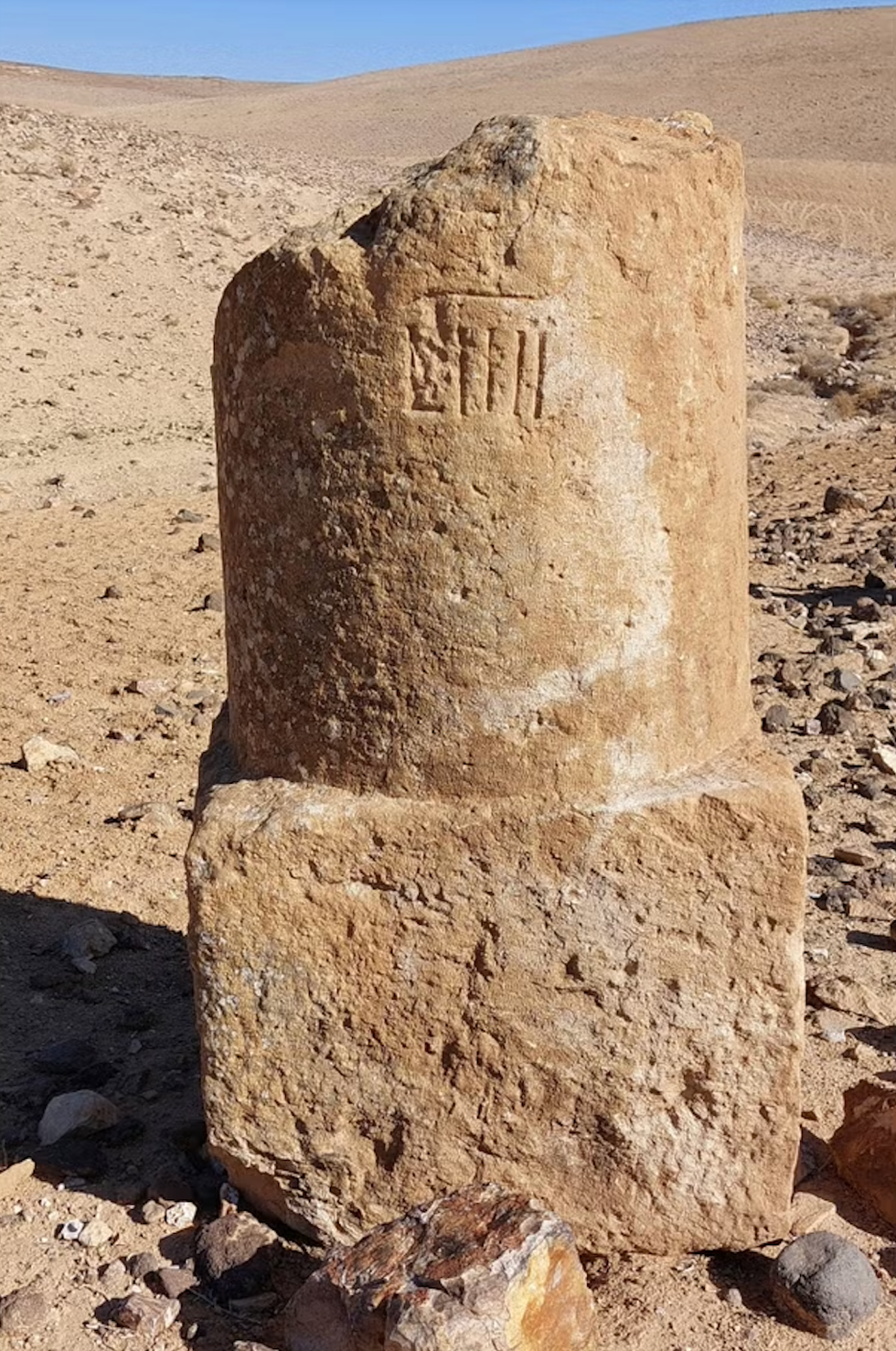 A photo provided by Adam Pažout of a Roman milestone fragment erected along the road Via Nova Traiana in JordanAdam Pažout/Itiner-e via AP
Having clear details about the ancient Roman routes helps us better understand life and trends during this time, particularly the movement of people, as this time period saw the rise of Christianity and deadly outbreaks.
“The Romans left a huge impact with this road network,” which created the blueprint for many roads still in use today, said study co-author and archaeologist Adam Pažout of the Autonomous University of Barcelona.
He added how Roman engineering such as arched stone bridges and tunnels through hillsides still impact geography and economy of the Mediterranean region.
The data and an interactive digital map are also available online for scholars, history teachers or anyone with an interest in ancient Roman history.
Elsewhere from Indy100, ‘Beautiful’ Roman mosaic depicting dolphins and fish uncovered in Shropshire dig, and Roman armour to go on display after experts complete ‘ancient jigsaw puzzle’.
How to join the indy100's free WhatsApp channel
Sign up to our free indy100 weekly newsletter
Have your say in our news democracy. Click the upvote icon at the top of the page to help raise this article through the indy100 rankings.